What is Hydrologic Unit Map
The Ministry of Land, Infrastructure and Transport, Ministry of Agriculture, Food and Rural Affairs and Ministry of Entvironment and so on are the central ministry that manages water in South Korea. The central ministry classified the national administrative work through the development of "Hydrologic Unit Map"which divides South Korea basins into the concept of city, province in administrative district1), sub-basins(the concept of city, county, district), and standard basins(the concept of city, county and district) to manage the river and water in South Korea.
Classification of the Hydrologic Unit Map
The Hydrologic Unit Map is classified into 21 large - sized areas(basin), 117 medium - sized areas(subbasin), and 850 small - sized areas(standard basin).
Basin is divided according to the 5 largest basins2) of Korea(Han River, Nakdong River, Geum River, Seomjin River, and Yeongsan River). Sub - basin is divided based on the meeting points of natural rivers3) and the major is lands of the southern and western sea. Lastly, standard basin is divided on the basis of the point where national4) and regional rivers5) gather, the point where the dam is located and the area where major facilities that manage waters are located. The boundary of basin in the Hydrologic Unit Map is divided by the watershed and the boundary where rain or snow runs into the other side of the river.
1)Administrative district : The area divided by the government ministry to manage population, land etc. (sorted into metropolitan, city, district, town)
2)Basin : is an extend of an area of land where surface water from rain and melting snow or ice converges to a single point at a lower elevation such as river.
3)Natural river : A river without an artificial embankment.
4)National river : Ministry of Land, Infrastructure and Transport designates the river name and sections according to Law of river. (This river is important for national land conservation and national economy.)
5)Regional river : Mayors and governors designate the river name and sections according to Law of river. (This river has a close relation with public interest.)
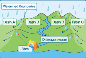
What is Watershed Boundaries?
 A watershed is an area where all rainfall collects into a common location. The common location could be a stream, a pond, a river, etc. It's also called a dividing ridge because it is usually made up of ridges and mountain ranges.
Basin is an extend of an area of land where surface water from rain and melting snow or ice converges to a single point at a lower elevation such as river.
In South Korea, Han River, Nakdong River, Geum River, Yeongsan River, and Seomjin River are the 5 major river systems. A river system is defined as the entire areas within a watershed boundary.